2025 Antietam Creek Watershed Report Card

On June 12, 2025 Antietam-Conococheague Watershed Alliance released the first Antietam Creek Watershed Report Card at a public reception and stewardship drop-in. Overall, The Antietam Creek Watershed scored 48%, a C grade, showing some areas of strength and other areas needing improvement.
Watershed report cards are powerful tools used around the world to describe ecosystem status, increase public awareness, and inform decision makers. This document assesses ecosystem health of the creek and watershed. The report card was developed by the Antietam-Conococheague Watershed Alliance (ACWA), Beaver Creek Watershed Association (BCWA), and the University of Maryland Center for Environmental Science (UMCES).
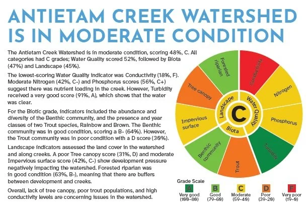
The report card evaluates nine indicators in three categories; water quality, biota, and landscape. Overall, the highest scoring category was Water Quality (52%), followed by Biota (47%) and Landscape (45%). Overall, lack of tree canopy, poor trout populations, and high conductivity levels are concerning issues in the watershed.
LANDSCAPES INFLUENCE STREAM QUALITY
Activities on land directly impact water quality. Construction of roads, buildings, and warehouses create hard, impervious surfaces that water runs off, taking pollutants, grit, and heat into streams. Land use in the Antietam Creek Watershed varies dramatically by location. Impervious surfaces cover 7% of the Watershed, earning a moderate Impervious surface score of 42%. Most impervious surfaces are in the western half of the watershed, in the City of Hagerstown. Less than 40% of the Antietam Creek Watershed is forested, earning a poor Tree canopy score of 31%.
Beaver Creek is the largest subwatershed within the Antietam Creek Watershed and contains unique habitat and sensitive aquatic species. This subwatershed has just over 4% Impervious surface coverage, earning a good score of 60%. Approximately 50% of the Beaver Creek Watershed is forested, earning a moderate Tree canopy score of 51%.
The presence of riparian forest cover (100 feet on each streamside) is critical to maintaining healthy streams. The Chesapeake Bay Agreement has set a target of 70% riparian tree canopy coverage by 2025. In the Antietam Creek Watershed, Riparian Forest covers only 47% of the overall watershed. Riparian areas within Hagerstown are only 39% covered, while Beaver Creek measures 51% of forested riparian area.
Overall, actions to support natural landscapes are needed, including protecting and restoring forests and riparian areas, reducing impervious surfaces, and using green stormwater practices. This improves communities by reducing flooding, providing green space, and supporting recreation activities.

Frequently Asked Questions:
What is being done about the high bacteria levels?
Bacteria are everywhere in our environment, but some bacteria can make water unsafe for contact. The bacteria can come from many sources such as livestock manure, residential septic systems, overflowing sewer lines, and even pet waste. Wildlife can also input bacteria, but generally not in high concentrations.
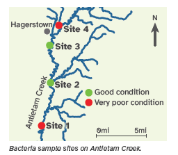
E. coli is used as an indicator of possible harmful bacteria in the water. High numbers of E. coli represent an increased risk to humans of becoming sick after coming in contact with the water. In Antietam Creek, weekly summer bacteria monitoring results were high at Sites 1 and 4 during both wet and dry weather events. This means that bacteria remains at high levels in our streams without experiencing input from stormwater runoff.
Despite many decades of high bacteria levels and monitoring by local organizations, it is unclear the primary source of bacteria on the Antietam mainstem. Most recently, the Potomac Riverkeeper Network has initiated extensive sampling efforts throughout the entire Antietam watershed to help identify bacteria hotspots. Samples are also being analyzed using new “source detection” methods to determine whether primary bacteria are from agricultural, human, pet, or wildlife sources. We anticipate results from this program in 2026.
What is Conductivity?
Conductivity is a measurement of ion balance in water. When conductivity levels are high, the ecosystem cannot maintain a salt balance. Ions dissolved in our streams may be natural but can also wash into our streams from pollutants, such as salts, chlorides, potassium, and sulfates as examples.
Conductivity is a sensitive indicator that demonstrates a direct source of pollution. Pollution sources of chlorides may include: urban stormwater runoff, road salts, wastewater treatment plants, failing septic systems, hydraulic fracturing, and industrial discharges.
Natural conductivity levels can vary dependent on underlying geology. Here in the western Maryland (the piedmont region), streams can have higher conductivity compared to eastern coastal regions. This natural variation is considered when scoring the Antietam’s conductivity results.